Rainfall totals skyrocket in Florida as Invest 90-L brings plenty of showers
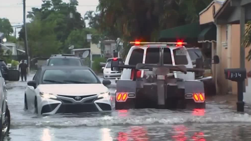
In some areas of Florida, rainfall amounts are nearing 10 inches for the week. The rainfall totals in Florida have increased significantly this year, with significant rainfall in parts of Central Florida, particularly in South Florida. The heavy rainfall has caused flash flooding in some areas including South Florida, where some areas have seen three and a half of three-and-a-half inches of rain. This has led to concerns about potential flooding and health issues. METEOROLOGIST ERIC BURRIS discusses these concerns with a FLOOD ADVISORY posted for RURAL SOUTHERN OSCEOLA County near the KISSIMMEE RIVER, which has seen 6.5in of rainfall in the last six hours of the last week alone. Despite these concerns, the weather has been mild, with no major issues reported so far.
Yayınlanan : bir yıl önce ile https://www.facebook.com/, Averi Kremposky içinde Weather
THIS YEAR. CENTRAL FLORIDA IS NOT THE ONLY AREA SEEING A LOT OF RAIN THIS WEEK. HEAVY RAINFALL TRIGGERED FLASH FLOODING IN PARTS OF SOUTH FLORIDA YESTERDAY. LOOK AT THESE CONDITIONS. PRETTY DANGEROUS OUT ON THE ROADS, RAIN ALSO FLOODED A MOBILE HOME PARK IN HIALEAH AS WELL AS OTHER NEIGHBORHOODS. REALLY, THE VISUALS SAY IT ALL AS WE TAKE A LOOK AT WHAT THIS RAIN HAS BROUGHT IN SOUTH FLORIDA, AND WE HAVE BEEN SEEING OUR OWN DOWNPOURS, A LOT OF WHICH ARE WELCOME HERE. BUT WE REALLY NEED YEAH, WE COULD USE SOME MORE RAIN. WE JUST DON’T WANT IT TO ALL COME DOWN IN A SHORT PERIOD OF TIME. AND AS WE BRING IN METEOROLOGIST ERIC BURRIS, WE KNOW THAT’S ONE OF THE THINGS, ERIC, THAT WE DID SEE HAPPEN FOR FOLKS IN SOUTH FLORIDA. YEAH, I MEAN, JUST WITHIN LIKE A ONE HOUR TIME FRAME, AREAS NEAR SARASOTA GOT THREE AND A HALF OR SO INCHES OF RAIN, WHICH WE GET THAT. AND ARE FINE. THEY ARE NOT. THEY FLOODED WILDLY AND THAT ACTUALLY SET THE ALL TIME ONE HOUR RECORD FOR THEM. BUT TAKE A LOOK AT SOME OF THESE RAINFALL TOTALS. NO NUMBERS OVER THE LAST WEEK OKAY. AROUND BRADENTON OVER. NINE INCHES OF RAIN NEAR SARASOTA, OVER SEVEN. AGAIN, OUR AREA IS JUST UNIQUELY SET TO WHERE WE’RE ABLE TO HANDLE IT. AND THE REASON, I MEAN, LOOK AT THE COMPARISON RIGHT OVER THE LAST COUPLE OF DAYS, TITUSVILLE AND THE CAPE CANAVERAL NATIONAL SEASHORE HAVE GOTTEN OVER SIX INCHES OF RAINFALL. SO WE’RE NOT TALKING ABOUT FLOODING HERE. THERE’S THE DIFFERENCE, RIGHT. AND MORE RAIN CERTAINLY IS IN THE FORECAST TOWER CAM NETWORK SHOWING ALL THE CLOUDS, TEMPERATURES OUT THE DOOR IN THE 70S. BUT I DO WANT TO TALK ABOUT SOME OF THAT RIGHT. THERE IS A FLOOD ADVISORY POSTED FOR RURAL SOUTHERN OSCEOLA COUNTY RIGHT ALONG THE KISSIMMEE RIVER HERE. THAT GOES UNTIL 845. BUT LOOK AT WHY, JUST IN THE LAST. SIX HOURS TIME, DOPPLER RADAR INDICATING 6.5IN OF RAINFALL HERE. THAT’S A WILD NUMBER FOR RAINFALL. THANKFULLY NOT A BUNCH OF PEOPLE OUT THERE, BUT NEVERTHELESS. I MEAN, IF YOU HAD SIX INCHES IN SIX HOURS IN THE METRO, THERE WOULD PROBABLY BE SOME ISSUES. THAT’S NOT THE CASE THOUGH. WE ARE TRACKING RAIN, JUST NOTHING QUITE AS HEAVY. HERE’S FIRST WARNING LIVE DOPPLER RADAR SHOWERS, EVEN SOME POCKETS OF HEAVIER RAIN. A LITTLE BIT OF RAIN WORKING UP TOWARD LEESBURG, CLERMONT SOME RAINS WORKING YOUR DIRECTION. MONTVERDE, LAKE APOPKA UP NEXT, SOUTH OF DOWNTOWN OAK RIDGE. WILLIAMSBURG, SEAWORLD, DOCTOR PHILLIPS, GOETHE. AREAS WITH SOME OF THESE SHOWERS AND THEN BACK OVER TO BREVARD. EXITING RAINS FOR COCOA BEACH, PORT CANAVERAL. BUT A GOOD STEADY RAIN FROM MELBOURNE DOWN THROUGH GRANT-VALKARIA AND MICCO. ALL OF THAT MOISTURE COMING IN BECAUSE OF THIS LITTLE PIECE OF ENERGY. THIS IS A TROPICAL WAVE. WE’VE TAGGED. INVEST 90 JUST MEANS THE NATIONAL HURRICANE CENTER IS RUNNING COMPUTER MODELS. THERE IS A CHANCE IT TRIES TO DEVELOP ONCE IT MOVES AWAY FROM US, BUT SINCE IT’S HERE, IT BRINGS US THE RAINFALL. THIS MORNING, 40% COVERAGE OF RAIN 9 A.M. A BIT DRIER AND THEN LUNCHTIME ON. WE START DIALING THE RAIN COVERAGE BACK UP TO AN 80% COVERAGE IN TERMS OF TEMPERATURES, CLOUDS AND RAIN LIMIT US TO THE MID AND UPPER RANGE OF THE 80S. A LITTLE BIT OF A BREAK MIDDAY ON FUTURE CAST, BUT NOTICE BY TWO THREE, 4:00 MORE, MORE AND MORE GREEN SHOWING UP. IT’
Rainfall totals skyrocket in Florida as Invest 90-L brings plenty of showers The National Hurricane Center is tracking a trough of low pressure — dubbed Invest 90-L — that is triggering plenty of showers in Central Florida and beyond.Some southern locations have seen rainfall amounts topping 9 inches this week alone. While the highest amount of rainfall has trended towards the southern portion of the state, Central Florida has certainly gotten its fair share of showers. Residents in West Titusville have seen just under 6.5 inches of rain this week. In Canaveral N. Seashore, the rainfall amount is at 6.30 inches for the week. The University of Central Florida saw 3.66 inches this week and Mims saw 3 inches.The amount of rain triggered a flood advisory in Volusia County on Tuesday night, and caused serious flash flooding in other parts of the state. While rainfall in Central Florida was high, the numbers farther south are even more staggering. In Bradenton, rainfall amounts are nearing 10 inches for the week. North Sarasota has seen 7.79 inches of rain this week, and Everglades City follows close behind with a weekly total of 7.75 inches. North Miami has seen 6.69 inches.Tracking the Tropics: What’s an invest? Invest 90-L started in the Gulf of Mexico and has slowly worked its way toward the western coast of Florida since being tagged by the NHC on Tuesday. It is expected to move across the state and off the southeastern coast as the week continues. According to the NHC, the invest has a very small chance of forming (10% in the next 48 hours and 20% in the next seven days). Formation is most likely once the low-pressure area moves off the Florida coast.Invest is short for "investigation" and refers to a weather feature that the NHC is investigating. It should be noted that it is not necessarily an area that is expected to develop into a tropical system. It’s simply an area being investigated for any number of reasons.>>> Related: WESH 2 Hurricane Survival Guide 2024>>> Related: Surviving the Season | 2024 Hurricane Special from WESH 2 The National Hurricane Center is tracking a trough of low pressure — dubbed Invest 90-L — that is triggering plenty of showers in Central Florida and beyond. Some southern locations have seen rainfall amounts topping 9 inches this week alone. While the highest amount of rainfall has trended towards the southern portion of the state, Central Florida has certainly gotten its fair share of showers. Residents in West Titusville have seen just under 6.5 inches of rain this week. In Canaveral N. Seashore, the rainfall amount is at 6.30 inches for the week. The University of Central Florida saw 3.66 inches this week and Mims saw 3 inches. The amount of rain triggered a flood advisory in Volusia County on Tuesday night, and caused serious flash flooding in other parts of the state. While rainfall in Central Florida was high, the numbers farther south are even more staggering. In Bradenton, rainfall amounts are nearing 10 inches for the week. North Sarasota has seen 7.79 inches of rain this week, and Everglades City follows close behind with a weekly total of 7.75 inches. North Miami has seen 6.69 inches. Invest 90-L started in the Gulf of Mexico and has slowly worked its way toward the western coast of Florida since being tagged by the NHC on Tuesday. It is expected to move across the state and off the southeastern coast as the week continues. According to the NHC, the invest has a very small chance of forming (10% in the next 48 hours and 20% in the next seven days). Formation is most likely once the low-pressure area moves off the Florida coast. Invest is short for "investigation" and refers to a weather feature that the NHC is investigating. It should be noted that it is not necessarily an area that is expected to develop into a tropical system. It’s simply an area being investigated for any number of reasons.